Datei:Palestine Map 2007.gif
Originaldatei (780 × 970 Pixel, Dateigröße: 103 KB, MIME-Typ: image/gif)
| Diese Datei stammt aus dem zentralen, freien Dateiarchiv Wikimedia Commons. Im Folgenden wird der Inhalt der dortigen Dateibeschreibungsseite angezeigt. |
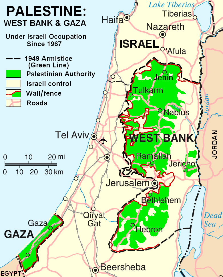
Beschreibung
This map is a modification, suggested as a replacement for the one uploaded by ChrisO at
which is used in the Wikipedia article "Palestine," under the History subheading Current Status.
My modification shows "facts on the ground" which are essential to any understanding of the situation in Palestine today. The geographic facts are not in dispute. They have been widely published in print and on the internet.
Both my map and the ChrisO map are modifications of a 2004 United Nations map of Israel:
(public domain) in which the three Occupied Territories, the West Bank, Gaza, and Golan, are given the same brown color as Israel's neighboring countries: Egypt, Jordan, Syria, and Lebanon. ChrisO colors the West Bank, Gaza, and Golan light green and renames the map "Israel and the Occupied Territories." However Golan is Syrian, not Palestinian. For an article on Palestine, attention should be on the West Bank and Gaza.
My modification crops out Golan and the Negev desert to focus in on the West Bank and Gaza. It also incorporates information from several published sources to show the land and resources actually available to Palestinian people in these two territories, the West Bank in particular.
The main source of information on barriers and land distribution comes from a map by the United Nations Office for the Coordination of Humanitarian Affairs:
supplemented by two more United Nations maps:
- http://www.ochaopt.org/documents/WB_Barrier_Projections_July06.pdf Archivkopie in der Wayback Machine
- http://www.ochaopt.org/documents/WB_Closure_Access_revised_CAP_June06.pdf Archivkopie in der Wayback Machine
Two Israeli organizations have published similar maps:
- http://www.btselem.org/Download/Separation_Barrier_Map_Eng.pdf
- http://www.icahd.org/eng/images/articles/the-matrix-of-control.gif Archivkopie in der Wayback Machine
And finally, the Washington Post published all this information on a full-page newspaper map:
Each of these maps is much too detailed to illustrate a Wikipedia article. My modification simplifies the information for use on a map similar in scale to the other maps in the article on Palestine.
Similar maps with locations of Israeli settlements are posted at:
.gif)
.gif&action=edit&redlink=1)
Lizenz
| Ich, der Urheberrechtsinhaber dieses Werkes, veröffentliche es als gemeinfrei. Dies gilt weltweit. In manchen Staaten könnte dies rechtlich nicht möglich sein. Sofern dies der Fall ist: Ich gewähre jedem das bedingungslose Recht, dieses Werk für jedweden Zweck zu nutzen, es sei denn, Bedingungen sind gesetzlich erforderlich. |
Dateiversionen
Klicke auf einen Zeitpunkt, um diese Version zu laden.
| Version vom | Vorschaubild | Maße | Benutzer | Kommentar | |
|---|---|---|---|---|---|
| aktuell | 18:03, 11. Apr. 2007 | | 780 × 970 (103 KB) | HowardMorland | |
| 23:37, 6. Apr. 2007 |  | 780 × 970 (101 KB) | HowardMorland | This map is a modification, suggested as a replacement for the one uploaded by ChrisO at http://en.wikipedia.org/wiki/Image:Israel_and_occupied_territories_map.png which is used in the Wikipedia article "Palestine," under the History subheading Curre | |
| 12:41, 5. Apr. 2007 |  | 780 × 970 (101 KB) | HowardMorland | This map is a modification, suggested as a replacement for the one uploaded by ChrisO at http://en.wikipedia.org/wiki/Image:Israel_and_occupied_territories_map.png which is used in the Wikipedia article "Palestine," under the History subheading Curre | |
| 01:49, 5. Apr. 2007 |  | 780 × 970 (101 KB) | HowardMorland | This map is a modification, intended to replace the one uploaded by ChrisO at http://en.wikipedia.org/wiki/Image:Israel_and_occupied_territories_map.png which is used in the Wikipedia article "Palestine" under the subheading "Current Status." My mod |
Dateiverwendung
Die folgende Seite verwendet diese Datei:
Globale Dateiverwendung
Die nachfolgenden anderen Wikis verwenden diese Datei:
- Verwendung auf en.wikipedia.org
- Verwendung auf eu.wikipedia.org